February 5, 2025

A Lifetime of Great Dogs: IV

Max looks on as Louise pets a heifer. 

 In April, 1992, a black dog appearing to be a spaniel/labrador mix wandered into Deer Run Farm while we were in the process of bringing in a larger mobile home. (Don was in Iraq and Kim, his wife, had come to live with us.)

A similar dog, but female, had been adopted by our good neighbors the Parris's about a week before. They named her Maria, and at first I thought this dog was Maria. Then I noticed he was a male, friendly, and with a jaunty air. I thought, this fellow is a maximum dog. So he became Mr. Maximum Dog, but Max to his friends. And he was our friend for the next twelve years. 

Which makes it all the more upsetting to me that this is the best photo I can find of him without going to the garage and digging through boxes of prints from the '90s.

Gladys and Max watch as Louise pets Freckles.

In those years we briefly had two other dogs -- Gladys, a small, collie-type, and Brigit, a border collie. Gladys was a nice dog, but she disappeared. We believe our other neighbor killed her for running his cattle. We think Brigit ran away, although we have never known for sure.

Max had demodetic mange, but thanks to Louise's loving care, lived a long, happy life. With sadness, we had him put to sleep when his life became burdensome to him.

I actually credit Max for saving our marriage. We finally sold our old house and were able to build on the farm in 1993 and '94. We had much difficulty with the contractor, and sometimes the tensions in our home were so great we could hardly speak to each other. So it became, "Max, tell your mother. . ." or Max, tell your father. . ."

Truly a maximum dog. I'll keep looking for a better picture.

More to come

Visit my online gallery at https://davejenkins.pixels.com/  

Signed copies of my book Backroads and Byways of Georgia are available. The price is $22.95 plus $3.95 shipping. My PayPal address is djphoto@vol.com (which is also my email). Or you can mail a check to 8943 Wesley Place, Knoxville, TN 37922. Include your address and tell me how you would like your book inscribed.

Photography and text copyright 2011-2025 David B.Jenkins.

I post Monday, Wednesday, and Friday unless life gets in the way.

Soli Gloria Deo -- For the glory of God alone.

Tags:   photography     family history   dogs

February 3, 2025

A Lifetime of Great Dogs: Part III

 Buffalo. A chow who was his own dog.

In December, 1987 we thought our house was sold, so we moved into a refurbished, 12x40-foot mobile home on our property in MacLemore Cove, intending to live in it until our new house was built. (The sale of our old house fell through, leaving us without enough money to build at that time. But that's another story.)

We brought with us to the Cove Harley and Schnoodles, and also our son Don's chow, Buffalo, since Don was in the Army by that time. Buffalo was a great dog, but very independent. He was happy with us, but he was his own dog. He disappeared after some months and we never saw him again. We don't believe he wandered off -- we have always believed our neighbor killed him.

Not long after we moved to the farm, I accidentally ran over Harley with the front wheel of my compact pickup truck. Incredibly, he lived. He had broken ribs and punctured lungs, but the vet put him in a sort of compression jacket and he recovered fully.

Sometime in 1989, we went into town for a few hours. When we returned we found both Harley and Schnoodles dead in our back yard. We believe they got into coyote poison that someone had put out. We mourned them, but were happy they both went together, so that one would not mourn for the other. They lived long, good lives -- 13 years for Schnoodles and 12 for Harley, and were a joy to us.  

Bear. My best buddy.

Later that year, some friends of Don, who was by this time at Fort Campbell, Kentucky, gave us a young chow, whom we named Bear. (As you can see, lots of imagination in our naming system.) Bear had a lot of personality and soon became my best buddy. Unfortunately, he was hit and killed by a car in 1991. Having pets is a life of love and loss, but very much worth it. We have been blessed by the dogs that have owned us.

To be continued.

Visit my online gallery at https://davejenkins.pixels.com/  

Signed copies of my book Backroads and Byways of Georgia are available. The price is $22.95 plus $3.95 shipping. My PayPal address is djphoto@vol.com (which is also my email). Or you can mail a check to 8943 Wesley Place, Knoxville, TN 37922. Include your address and tell me how you would like your book inscribed.

Photography and text copyright 2011-2025 David B.Jenkins.

I post Monday, Wednesday, and Friday unless life gets in the way.

Soli Gloria Deo -- For the glory of God alone.

Tags:   photography     family history   dogs

January 31, 2025

The Backroads Traveler Part II: On the Way to Tybee


Shrimp boats in Lazaretto Creek on the way to Tybee.

Tybee Island is a great destination, but there's also good stuff to see along the Islands Expressway from Savannah to the island. Including one you should not miss.

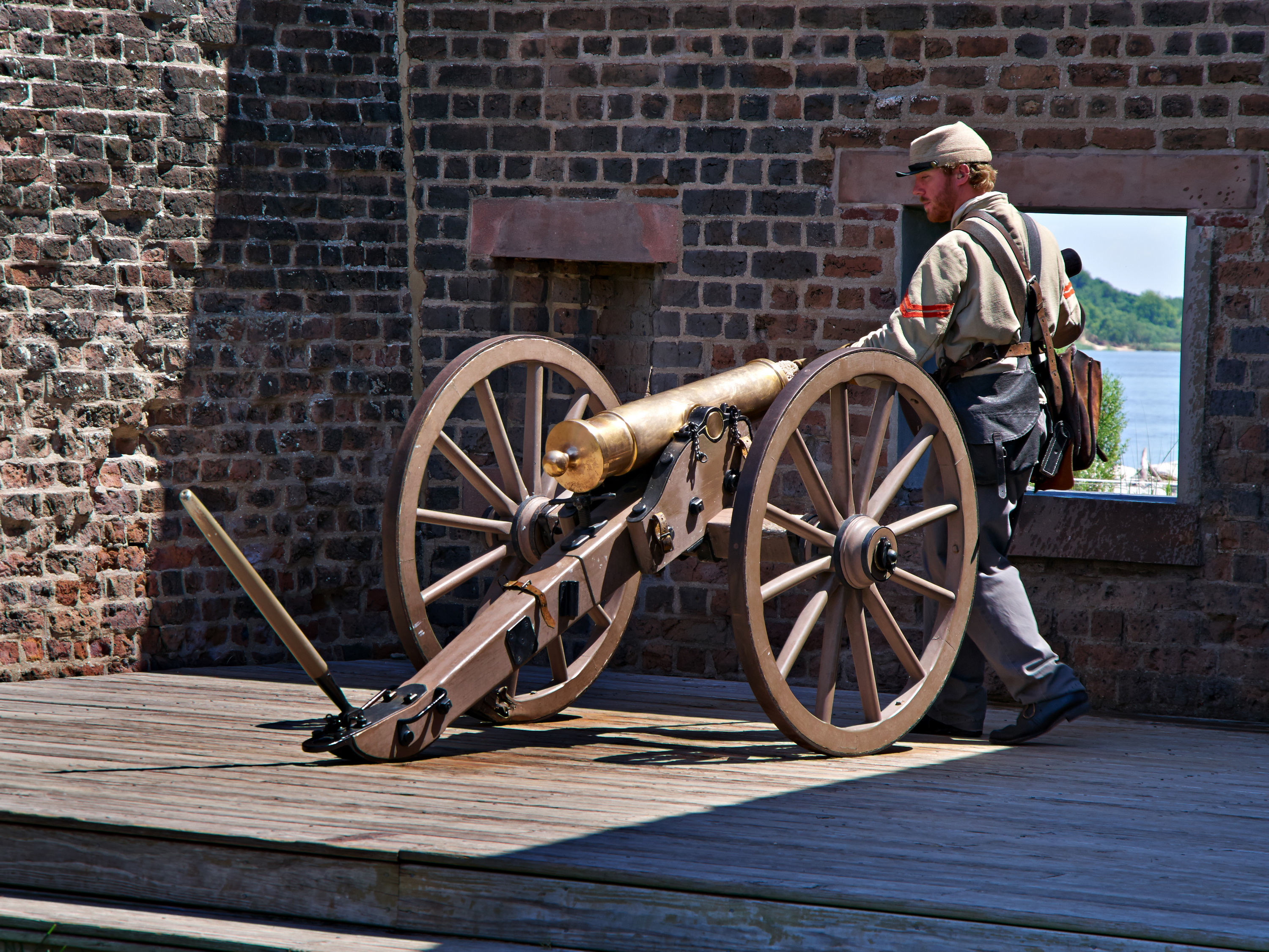
Preparing to fire the cannon at Fort Jackson.

Leaving Savannah via East President Street/Islands Expressway, turn left on Woodcock Street and follow it to Ft. Jackson Road and Old Fort Jackson, built in 1808 at a strategic location on the Savannah River as part of President Thomas Jefferson’s coastal defense system. After the fall of Fort Pulaski in 1862, Fort Jackson became the headquarters for all the river defenses protecting Savannah during the Civil War. It fell to Federal forces in 1864, as General Sherman culminated his March to the Sea by taking Savannah. 

The U.S. War Department abandoned the fort in 1905 and it is now operated by the Coastal Heritage Society as a museum dedicated to education and military history. Open seven days a week, 9 a.m. to 5 p.m., a demonstration of muzzle-loading cannon firing is given at 11 a.m. and 2 p.m. daily. There are also interactive programs for kids, adults, and families. 

Moat and wall at Fort Pulaski.

 From Fort Jackson, go back to Islands Expressway and go left (east) for ten miles to Fort Pulaski National Monument on the left.

Completed in 1847, its seven and a half–foot solid brick walls, backed up by concrete piers and earthworks, were considered impregnable. At the onset of the Civil War, it was seized by the State of Georgia, which then transferred the fort to the Confederacy. In November, 1861, Federal forces established a beachhead at Hilton Head Island, causing Confederate forces to abandon nearby Tybee Island. 

Inside the walls of Fort Pulaski.

The Federals brought in something new: rifled cannon capable of far greater range and power than anything previously known, and in April, 1862, set up batteries on the northwest shore of Tybee and swiftly proceeded to breach the “impregnable” walls of Fort Pulaski. The Confederate commander surrendered in just 30 hours. It was a turning point; the beginning of a new era in warfare.

From Fort Pulaski, continue east on Islands Expressway for about two miles, crossing Lazaretto Creek as you go, and turn right on Catalina Drive, then immediately left on Estill Hammock Road to the Crab Shack, a don't-miss destination!

 Lunch at the Crab Shack. Don't miss it!

Voted Savannah’s best seafood since 1998, the super-casual atmosphere at the Crab Shack might make you think you’ve stumbled upon a pirates’ hangout, but the food and service are worth walking the plank for. If you’ve never had their low-country shrimp boil, you are going to hate yourself for all the years you’ve wasted.

Also, don't miss the Tybee Island sunrise. It's worth getting up early for!

About the equipment: The photographs of the shrimp boats and sunrise were made with Olympus OM film cameras and (probably) Kodachrome 64 film, scanned with a Konica-Minolta DiMage 5400 scanner. For the other photos, I used an Olympus E-M5 digital camera with a Panasonic Lumix Vario-G 14-140mm lens.

Visit my online gallery at https://davejenkins.pixels.com/  

Signed copies of my book Backroads and Byways of Georgia are available. The price is $22.95 plus $3.95 shipping. My PayPal address is djphoto@vol.com (which is also my email). Or you can mail a check to 8943 Wesley Place, Knoxville, TN 37922. Include your address and tell me how you would like your book inscribed.

Photography and text copyright 2001-2025 David B.Jenkins.

I post Monday, Wednesday, and Friday unless life gets in the way.

Soli Gloria Deo -- For the glory of God alone.

Tags:   photography    travel     Olympus E-M5 digital camera     Panasonic Lumix G-Vario 14-140mm lens    digital photography    Olympus OM film camera     Tybee Island, Georgia    Kodachrome 64 film    Georgia coast     Tybee Island     lighthouses     film photography     U.S. Highway 80     Konica-Minolta DiMage 5400 film scanner     The Crab Shack     Fort Jackson, Georgia     Fort Pulaski National Monument

January 30, 2025

The Backroads Traveler: Tybee Island, Georgia

Sunrise at Tybee Island.

I prefer Georgia's mountains to its flatter lands, but everyone likes to go to the beach sometimes. And when you go, Tybee Island is the place to go.

As every Georgian knows, you get to Tybee by taking U.S. Highway 80 from Savannah. U.S. 80 originally ran 2,538 miles from San Diego, California to the beach at Tybee Island, but  now its western end is Dallas, Texas. 

'Most everyone who thinks about Tybee thinks about the beach, of course, but the island includes a community of about3,000 more-or-less permanent residents. With all the tourists occupying the many hotels, motels, and rental condos, the population is probably double that at any given time. Needless to say, the town's main industry is tourism.

The Tybee Island Lighthouse is open for tours.

While you're on the island, be sure to see the Tybee Island Lighthouse and Fort Screven. 

Completed in 1867, the lighthouse is 154 feet in height and is the fourth on this site, going back to 1736. The first two were wooden and did not survive long. The third tower was built of brick in 1773. When the Confederates abandoned Tybee Island, they attempted to blow it up with a keg of gunpowder, but its brick shell, twelve feet thick at the base, survived and forms the first 60 feet of the present lighthouse. The beacon, still with its original lens, continues to guide maritime traffic at the mouth of the Savannah River. The lighthouse keeper's house was built in 1881. The lighthouse is open for sunset tours on a limited basis, including climbing all 178 steps to the top. 

Fort Screven was finished in 1905, but decommissioned in 1947.

Fort Screven, the fortification adjacent to the lighthouse, was mandated by the state of Georgia in 1786, but construction did not actually begin until 1897, after the federal government took over the site. Completed in 1905, it was used as a coastal defense artillery fort and an infantry post and was decommissioned in 1947. Today, Battery Garland, one of six remaining batteries at Fort Screven, houses the Tybee Museum which, along with the Tybee Island Light Station, is operated by the non-profit Tybee Island Historical Society.
Also at Fort Screven is Officer’s Row, a group of houses with sweeping ocean views that were built as officer’s residences around 1900.The fort district was placed on the National Register of Historic Places in 1982.

 Drift fences help prevent erosion of the beach.

Other things to see on Tybee include the Tybee Island pier, which juts out into the Atlantic just off US 80 at Tybrisa Street. It’s a place for fishing, walking, and people-watching, and the pavilion at the end is available to rent for social functions. Also, while you’re near the pier, visit the Marine Science Center, located off the 14th Sreet parking lot. Their mission is “to cultivate a responsible stewardship of coastal Georgia’s natural resources through education, conservation, and research.” They offer walks, talks, and treks, maintain a gallery of exhibits of coastal Georgia flora, fauna, and habitats, and operate week-long sea camp ocean adventures for kids 6–11 each summer. They’re open Thursday to Sunday.

The dunes behind the beach at Tybee Island.

More about Tybee Island coming soon.  

About the equipment: A bit of guesswork here, because I've been to Tybe numerous times and and am not sure exactly when some of the pictures were made. The photos of the anchor, the drift fences, and the sand dunes were made with Olympus OM film cameras (best guess), probably on Kodachrome 64 film, and scanned with a Konica-Minolta DiMage 5400 scanner. The lighthouse and Fort Screven were photographed with an Olympus E-M5 digital camera fitted with a Panasonic 14-140mm lens.

Visit my online gallery at https://davejenkins.pixels.com/  

Signed copies of my book Backroads and Byways of Georgia are available. The price is $22.95 plus $3.95 shipping. My PayPal address is djphoto@vol.com (which is also my email). Or you can mail a check to 8943 Wesley Place, Knoxville, TN 37922. Include your address and tell me how you would like your book inscribed.

Photography and text copyright 2001-2025 David B.Jenkins.

I post Monday, Wednesday, and Friday unless life gets in the way.

Soli Gloria Deo -- For the glory of God alone.

Tags:   photography    travel     Olympus E-M5 digital camera     Panasonic Lumix G-Vario 14-140mm lens    digital photography    Olympus OM film camera     Tybee Island, Georgia    Kodachrome 64 film    Georgia coast     Tybee Island     lighthouses     Fort Screven     U.S. Highway 80     Konica-Minolta DiMage 5400 film scanner     beaches